Source Website: http://travel.asiaone.com/travel/inspirations/8-hiking-trails-singapore-you-should-try
By Geraldine Mark, Shopback, Tuesday, 20 Sepyrmber 2016

PHOTO: Urban Singapore is a concrete jungle where dreams are made of. Many yearn for a quick getaway around the region to escape their hedonistic lifestyles here. There are natural gems waiting to be uncovered around this supposedly concrete jungle.
Photographed by Michon Scott - Not in Singapore
https://blogger.googleusercontent.com/img/b/R29vZ2xl/AVvXsEgbbrKfoEygkOZPy6f063Oci3y8lnU-BmEorauyvqslP-mR7gwRlrxec_x73tWDs_evQyAKZ1ANFe7bENpSikePMjIl6Uhnenf6MnBq4gFz4pgZH8869GSuNjk_WZiCPlG-ER9x7uzV6VSr/s1600/en_cpphotohyl.jpg
http://www.strangescience.net/enlar/en_cpphotohyl.jpg
http://wesharepics.info/imageggkl-giant-lizard-monster.asp
There are times when we do not think of urban Singapore as a concrete jungle where dreams are made of. On these occasions, many yearn for a quick getaway around the region to escape their hedonistic lifestyles here.
But what if we told you that there are natural gems waiting to be uncovered around this supposedly concrete jungle. In this article, we find out more about hiking trails that you can opt for instead of the usual jogging trails.
1. Macritchie Reservoir Park and Treetop Walk

Photo: The Straits Times
https://blogger.googleusercontent.com/img/b/R29vZ2xl/AVvXsEiuh5S4q9rjrCeBt86Oi0ImO7uUPhkWoya7Vg768F0jbmxqVWHqvHS3SdcaO7TrvwpPQuNXJLN9DTk2Xj0J2UACRips1FoFC9yo4KJySAeUf1Sbx5WcsR5XethC0l_w0cfFhtr3I-jpsUQk/s1600/14260_1474333681.jpg
http://www.asiaone.com/sites/default/files/inline/images/14260_1474333681.jpg
http://travel.asiaone.com/travel/inspirations/8-hiking-trails-singapore-you-should-try
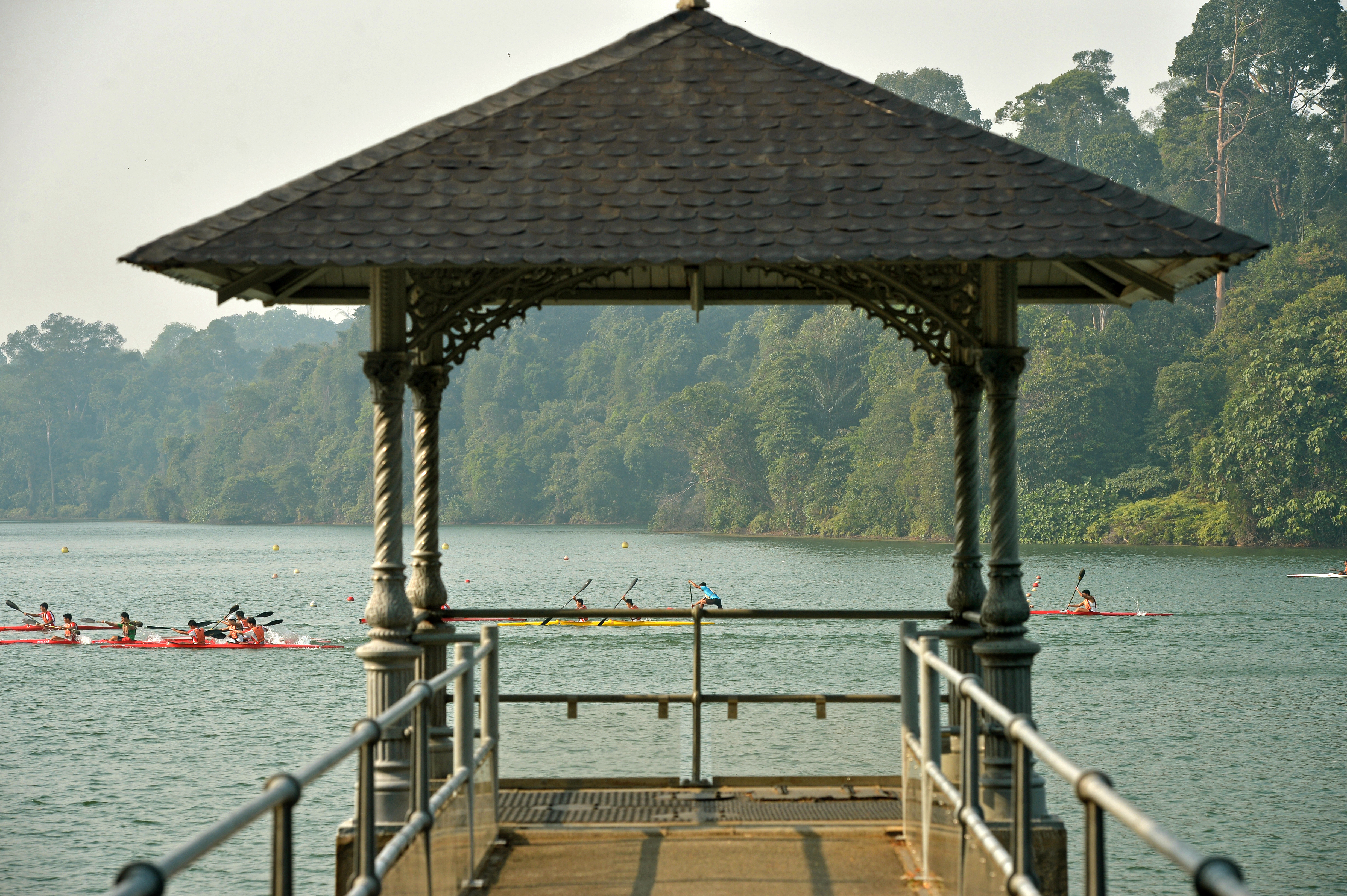
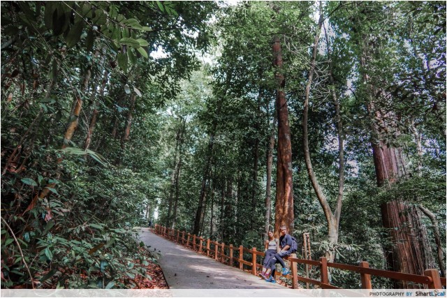
One of the most well-known hiking trails, Macritchie Reservoir is a friendly environment for all types of walkers.
The park is home to a variety of wildlife, and features a soothing tropical scenery and serene hiking paths of varying distances.

PHOTO: MacRitchie Nature Trail
As you walk into the area, an average-looking park will come into sight. But don’t turn your back just yet - keep going! As you approach the trails, you will step into a forest heaven you would never expect to find at a reservoir. I felt as though I was deep in the woods, and strolling on the boardwalk next to calm waters was exhilarating. I’d be jealous if you live nearby.
Posted by Esther Tam on Monday, 23 November 2015
https://blogger.googleusercontent.com/img/b/R29vZ2xl/AVvXsEhxlDgOuNuPSXXoLwZFVHaNPVd55guMnOjOnCWA17O6bBH0fun8sD0a3-giuNp7Giz9B-QefcXQh_ZqUfCUkSIOSr_pRbrrZZoXrbKuri7F_2O5HPqkrpTg7ngfyE6Q_NmZXg-2s-3pImcn/s1600/b2ap3_medium_image09.jpg
http://www.thesmartlocal.com/images/easyblog_articles/2626/b2ap3_medium_image09.jpg
http://thesmartlocal.com/read/hiking-trails
The park is also home to the popular HSBC Treetop Walk, an aerial walkway that grants you a bird's eye view of the rainforest's canopy and the occasional flying lemur. If you are lucky (or unlucky), you might be able to get up close and personal with the infamous macaques, known for their brazen demands for food from nearby humans.
PHOTO: MacRitchie Reservoir treetop Walk, an aerial walkway that grants you a bird's eye view of the rainforest's canopy. It is super popular among nature lovers. The TreeTop walk is a 250 meter suspended pathway between the 2 highest points in MacRitchie, Bukit Peirce and Bukit Kalan. At the TreeTop Walk's highest point, you'll be 25 meters above the ground - that's up to 7 storeys high!
Picture posted by Arwa Lodhi, Eluxe Magazine
https://blogger.googleusercontent.com/img/b/R29vZ2xl/AVvXsEivHmRTRQOG6wiZFfheFihFRJC2EpLK9XLjKLKIsYE53TuNzSOj4L7C_1u8kLBGEZRS9y0LFA7qfRGndXCBiVhOCiWfhqEq1pT6r41AraBE6-lcP1cgXf1iqCR309FAOol_fPcUZYeZYuhb/s1600/1261221_orig.jpg
http://eluxemagazine.com/wp-content/uploads/2016/02/1261221_orig.jpg
http://eluxemagazine.com/travel/sustainable-singapore/
PHOTO: The Jelutong Tower is a must-visit. Being at the top was so worth it up there with the forest canopy spread across in the background. To give you an idea of the view, this is what you see when you look down. You have to go up and see it for yourself.
Plus, you get to sit. On the TreeTop Walk, you might be blocking someone's way if you just plonk down on the bridge, which you shouldn't be doing anyway. At the tower, we just sat there and took amazing photos and had great conversation and talked about what we were going to have for dinner. What a wonderful place.
Posted by Cheryl Suah on Thursday, 05 March 2015
https://blogger.googleusercontent.com/img/b/R29vZ2xl/AVvXsEg3BW3oNqfawgcj-Vj7EiZFTY6sZjpiEx-b4GfPdxTthedNOzd_MBWKW6Yac-cG4KaormAiX9nVsjLsOt_aZhia34lV_zyPUGor9_Dp5aEYaX6M0JQLeSZG6Mh7ruKoJ_7YsHidVAyLY5E8/s1600/Macritchie-18_20150304-072555_1.JPG
http://thesmartlocal.com/images/easyblog_images/2337/Macritchie-18_20150304-072555_1.JPG
http://thesmartlocal.com/read/macritchie-treetop-walk
2. Bukit Timah Nature Reserve

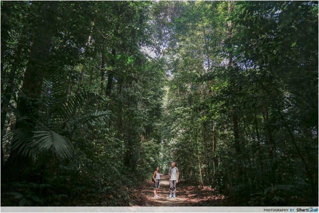
Bukit Timah Nature Reserve is a favourite amongst Singaporean hikers. This is probably due to its status as the tallest natural hill in Singapore (163.8m) and the steep slopes. If you’re up for a challenge, this is the place to go. Unlike other locations that pace you bit by bit, the trail here only inclines and a 0.2 km flight of uneven steps awaits you at the end. Our thighs definitely felt it the next morning.
Picture posted by Esther Tam on Monday, 23 November 2015
https://blogger.googleusercontent.com/img/b/R29vZ2xl/AVvXsEjPLI-21uosG4sspRSTwHy4qo25rtI2NFV6xFyQAqRrg2S6NXPU_iYJy_Ts2AcqBEkj447u8fRbNvpdvrNGWkCt_aGYz8IPW_PbtLz7TMa52t3ea-Ay-7USYwBia4_mLynOVS3aqFWyl7sl/s1600/b2ap3_medium_image20.jpg
http://thesmartlocal.com/images/easyblog_articles/2626/b2ap3_medium_image20.jpg
http://thesmartlocal.com/read/hiking-trails
The highest natural peak in Singapore may not have much to offer in terms of a view, but it has a tranquil feel with plenty of trails for you to pick from in the nature reserve. One of them is the mountain biking path tackled by cyclists. The hill is also of historical significance as it is where the British military made its final stand against the invading Imperial Japanese Army.

PHOTO: Hindhede Quarry at the Bukit Timah Nature Reserve
Posted by Jerlin Tan on Sunday, 26 February 2012 at 11:59 pm
https://blogger.googleusercontent.com/img/b/R29vZ2xl/AVvXsEgmXn3gCseFT04kRHVWXSIMz7y5Ub53Z7DAJtvdPltl5mz4Gi-Sn7y9mIgZyKhWvZbcyVOIAOhoGr8LNBPtO2M2V9UI5STEP0kQbmeN_WvSPpUNCkywkqdMyxqTguf_saS-OE6JTx2cTmlJ/s1600/P1110277.JPG
http://3.bp.blogspot.com/-KJWLnESkSLA/UR8Ew_3A3WI/AAAAAAAATfI/3lRiV764LTY/s1600/P1110277.JPG
http://wodejiaoying.blogspot.sg/2012/02/bukit-timah-nature-reserve.html
For the more adventurous, the Bukit Timah Nature Reserve can be the second destination after Macritchie Reservoir, an additional 6km past the treetop walk.

PHOTO: Bukit Timah Nature Reserve - Explore the astonishing biodiversity
This reserve includes Singapore’s highest hill, Bukit Timah, at a mere 164m (538ft), and protects 163 hectares (403 acres) of the nation’s only virgin lowland rainforest. There are five walking trails, all clearly marked and with varying levels of difficulty, taking from 45 minutes to 2 hours to complete.
Photo by Vincent Ng
https://blogger.googleusercontent.com/img/b/R29vZ2xl/AVvXsEgvVtjhRBHGlXn5-7v9R5XAcJz4ROl9jww0IK8ypytaKIu9u1OUey5kE_9uWJTP8-_D-wSiHOLjjDJ1Ltgs7r4Al8Gx0EM_Ho9lfyaTZjla-eyZdYkmP-IfIBOqHwMM0ZiB2HIyXX-p0z0/s1600/eea74d7d-88be-4a7b-8676-ee75dba74293.jpg
https://d3vonci41uckcv.cloudfront.net/old-images/original/eea74d7d-88be-4a7b-8676-ee75dba74293.jpg
https://www.insightguides.com/destinations/asia-pacific/singapore/singapores-outer-areas/overview
3. Southern Ridges
Posted by Jerlin Tan on Sunday, 26 February 2012 at 11:59 pm
https://blogger.googleusercontent.com/img/b/R29vZ2xl/AVvXsEgmXn3gCseFT04kRHVWXSIMz7y5Ub53Z7DAJtvdPltl5mz4Gi-Sn7y9mIgZyKhWvZbcyVOIAOhoGr8LNBPtO2M2V9UI5STEP0kQbmeN_WvSPpUNCkywkqdMyxqTguf_saS-OE6JTx2cTmlJ/s1600/P1110277.JPG
http://3.bp.blogspot.com/-KJWLnESkSLA/UR8Ew_3A3WI/AAAAAAAATfI/3lRiV764LTY/s1600/P1110277.JPG
http://wodejiaoying.blogspot.sg/2012/02/bukit-timah-nature-reserve.html
For the more adventurous, the Bukit Timah Nature Reserve can be the second destination after Macritchie Reservoir, an additional 6km past the treetop walk.
PHOTO: Bukit Timah Nature Reserve - Explore the astonishing biodiversity
This reserve includes Singapore’s highest hill, Bukit Timah, at a mere 164m (538ft), and protects 163 hectares (403 acres) of the nation’s only virgin lowland rainforest. There are five walking trails, all clearly marked and with varying levels of difficulty, taking from 45 minutes to 2 hours to complete.
Photo by Vincent Ng
https://blogger.googleusercontent.com/img/b/R29vZ2xl/AVvXsEgvVtjhRBHGlXn5-7v9R5XAcJz4ROl9jww0IK8ypytaKIu9u1OUey5kE_9uWJTP8-_D-wSiHOLjjDJ1Ltgs7r4Al8Gx0EM_Ho9lfyaTZjla-eyZdYkmP-IfIBOqHwMM0ZiB2HIyXX-p0z0/s1600/eea74d7d-88be-4a7b-8676-ee75dba74293.jpg
https://d3vonci41uckcv.cloudfront.net/old-images/original/eea74d7d-88be-4a7b-8676-ee75dba74293.jpg
https://www.insightguides.com/destinations/asia-pacific/singapore/singapores-outer-areas/overview
3. Southern Ridges

Follow the wavy trail along The Southern Ridges
Photo: Kenneth Pinto, Flickr Commons
https://blogger.googleusercontent.com/img/b/R29vZ2xl/AVvXsEhYuZK0rT8owDbMNfZ9YM1VhTzwX6co2lx_0DpVrrw6HKAeHVhJYGew_yncUwZMTebQgleAOzVSnJmnT6D3yKwGM6AUoKKyTGiX5s-ivsMvVtAaUt969BA3Sh9n2E9ECLErvnq_hzqJugVX/s1600/Southern+Ridges+Flickr+Kenneth+Pinto.jpg
http://www.expatliving.sg/incoming/article77427.ece/alternates/w1024/Southern%20Ridges%20Flickr%20Kenneth%20Pinto.jpg
http://www.expatliving.sg/Things_to_do/things_todo_news/35-things-to-do-in-Singapore-Huge-guide-to-cool-activities-on-the-Red-Dot-77419.ece
The Southern Ridges is a 10km connector trail that links to five other parks (Mount Faber, Telok Blangah Hill Park, HortPark, Kent Ridge Park and Labrador Nature Reserve).

PHOTO: The Southern Ridges is a 10km connector trail that links to five other parks (Mount Faber, Telok Blangah Hill Park, HortPark, Kent Ridge Park and Labrador Nature Reserve).
Photo Courtesy of escape.wordpress.com
https://blogger.googleusercontent.com/img/b/R29vZ2xl/AVvXsEhI_JN-DDXRK0S0wn6SCCKm5nGvmcWKKI2CzhbJNZ9oj7gIUyoMBKSkNrzB2Li-kad5QaXz8DrUPGwIhX0Okq3fSEQ2RgFiTN_F_x1Iw3eMsvVZq3FhDGmYzW7P7hzQlGWaic0-lTo67c0m/s1600/dscn3962_crop-659x494.jpg
http://singaporewest.sg/wp-content/uploads/2015/07/dscn3962_crop-659x494.jpg
http://singaporewest.sg/go/5-must-explore-jogging-trails/
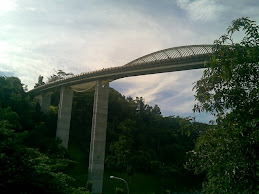
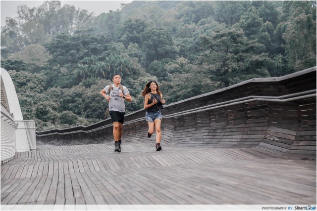
The trail is suitable for hikers at different levels as there are multiple entry points which allow you to tweak your journey according to personal preference and convenience. A popular trail is the journey along Henderson Waves, Singapore's tallest pedestrian bridge which connects Mount Faber to Telok Blangah Hill Park.

Photo Courtesy of escape.wordpress.com
https://blogger.googleusercontent.com/img/b/R29vZ2xl/AVvXsEhI_JN-DDXRK0S0wn6SCCKm5nGvmcWKKI2CzhbJNZ9oj7gIUyoMBKSkNrzB2Li-kad5QaXz8DrUPGwIhX0Okq3fSEQ2RgFiTN_F_x1Iw3eMsvVZq3FhDGmYzW7P7hzQlGWaic0-lTo67c0m/s1600/dscn3962_crop-659x494.jpg
http://singaporewest.sg/wp-content/uploads/2015/07/dscn3962_crop-659x494.jpg
http://singaporewest.sg/go/5-must-explore-jogging-trails/
The trail is suitable for hikers at different levels as there are multiple entry points which allow you to tweak your journey according to personal preference and convenience. A popular trail is the journey along Henderson Waves, Singapore's tallest pedestrian bridge which connects Mount Faber to Telok Blangah Hill Park.
PHOTO: Henderson Waves, a popular trail with scenic views
Picture posted by Esther Tam on Monday, 23 November 2015
https://blogger.googleusercontent.com/img/b/R29vZ2xl/AVvXsEh-b1e8XA8z-l9_rgFZHRqVyz0vK2fCOX_12wjV_bhIkaFicuoeCqGPhcUwi02HeXoT55gsSbSOcJ_iVFU306h2zTkMjWsbScbFMQk68zLpmiNfTgu-OlN9ewWQeYhOhgb_rSfTDISKI3aM/s1600/b2ap3_medium_image15.jpg
http://thesmartlocal.com/images/easyblog_articles/2626/b2ap3_medium_image15.jpg
http://thesmartlocal.com/read/hiking-trails
4. Pulau Ubin

Picture posted by Gerard Goh, flickr, taken on 30 July 2006 - Pulau Ubin - Granite Quarry
https://blogger.googleusercontent.com/img/b/R29vZ2xl/AVvXsEjdPWUIIOEu2soEZrr8ytTVKXy9ZFWCTjMDudvEyV1qx1_I5gMXExYf1iFDhPplXHjFptaEh5JrDRpjVHDHen1gJD6tD9qSBnnGq11mrXDk2uXUKNIgfq-OLiWi4Voy0smN5lueLvT_tKgc/s1600/202440850_6d85813584.jpg
https://c1.staticflickr.com/1/62/202440850_6d85813584.jpg
https://www.flickr.com/photos/gerardgoh/202440850
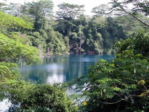
Head to Pulau Ubin if you want to completely detach yourself from the urban jungle of Singapore. A bumboat journey away, a hike in Pulau Ubin will transport you back in time. Opt to visit the island during low tides where you can head to Chek Jawa and check out the intertidal wildlife in action such as the male fiddler crabs. Or, trek up to Bukit Puaka and enjoy the view of the Ubin quarry.

PHOTO: "I stepped foot onto this island again a few weekends ago. It was like stepping into a part of Singapore where time has stood still and life was much simpler. Little did we know that Pulau Ubin was so photogenic - with lush greenery and a wide array of wildlife, the sights were endless.
Pulau Ubin literally means Granite Island in Malay, which is appropriate for an island which is largely made up of granite hills - in the past, granite mining was the main industry for the residents of the island."
Posted byFauzi Aziz on Friday, 12 December 2014
https://blogger.googleusercontent.com/img/b/R29vZ2xl/AVvXsEhquIGmLe617d2XHpitrq9NNbfLKHfTgNCMWJrOqLn4O17yNJf22F-Sr7q5CVSNLGKLS3o4ZsuSCPC-NH8Fj5RrPbdYRiIcg8bdXdZu9XgMjXZOd3JN3PfXX5TxCvj10xq7QunkjT6omIhA/s1600/Pulau-Ubin-28.JPG
http://thesmartlocal.com/images/easyblog_images/2304/Pulau-Ubin-28.JPG
http://thesmartlocal.com/read/instawalk-ubin
PHOTO: Bukit Puaka, peak of the quarry. A trip to Pulau Ubin is awesome and worth the small cost. Pulau Ubin is of the few islands left with nature and traditional kampong houses in Singapore.
Posted by Jobyna Teo on 20 April 2014
https://blogger.googleusercontent.com/img/b/R29vZ2xl/AVvXsEjmLpa7H2R32RDmcaYGDQXoaozkMR7rBzpGwOyWbqo03kMjC-bxAb2l-S7X_qSS4fioecbd2TtvgW4c3Co14ORO9zf5Os8FxDxgZyMRsjH1wIGu3l99pKGFkPFPtrdKlXhe1SVn6E1jNmrm/s1600/img_4374-1.jpg
https://jobynateo.files.wordpress.com/2014/08/img_4374.jpg
https://jobynateo.wordpress.com/2014/04/20/nature-singapore-pulau-ubin/
Alternatively, a trek or cycle through the island amidst the family of wild boars is a great way to soak in the laid-back atmosphere reminiscent of Singapore in the 1960s.
PHOTO: Chek Jawa
There are several mesmerizing offshore islands in Singapore, which are tailored to the longings of solitude seekers. Pulau Ubin, off the eastern coast of Singapore, is a laid back settlement with mangrove forests, muddy tracks and rustic wooden houses. The island gives you the essence of Singapore which is soaked up in 1960’s style. Explore the island on a bike or just hike through the dirty trails. Chek Jawa, which is a protected mangrove, is arguably the principal attraction of the island.
Picture courtesy – staticflickr.com
Posted by TraveleZe on 12 August 2015
https://blogger.googleusercontent.com/img/b/R29vZ2xl/AVvXsEg4QWLxAhBSppPu3RAxzoaup1hbm7bmJWKN318lEe3I3mfdfdue8-ZFSUKxyNGEQrcOlw-ksAzm2TSNaGl0Y8ac21FthDwja3QjmBfT_1PKIFWEPehvf07O_tMG8jBRVCloZ-zZMAPa7JjW/s1600/510.jpg
https://travelezeuk.files.wordpress.com/2015/08/510.jpg
https://travelezeuk.wordpress.com/2015/08/12/the-unfathomable-green-shelters-of-singapore/
PHOTO: Palau Ubin, the Unfathomable Green Shelters of Singapore
Picture courtesy – travelwithjoshcohen.com
Posted by TraveleZe on 12 August 2015
https://blogger.googleusercontent.com/img/b/R29vZ2xl/AVvXsEh4IcQ3xoTAbr2l7ilzmTZmKvASV_5nAc6xpU7wiR_0TNpIde5tNOIyY4U0JKamQVv3aB6JS6XJYOFyaRXS9zQtWPtY-1akCjh1NS8zATNYqVVZKHB3fSWaPGdbtxGHHOcNMQ3YkpLwkNi0/s1600/310.jpg
https://travelezeuk.files.wordpress.com/2015/08/310.jpg
https://travelezeuk.wordpress.com/2015/08/12/the-unfathomable-green-shelters-of-singapore/
5. The Green Corridor
PHOTO: The black railway truss bridge
With greenery on both side of the path, this is an excellent trail for walking, cycling and at the same time serving as a wildlife corridor.
Posted by Anthony Quek on September 22, 2015
https://blogger.googleusercontent.com/img/b/R29vZ2xl/AVvXsEg1wrNjsnUB8JfhZT1WAH1dzI_AArlve8wpaJOecgD6dD_YVh6Ne-9i5Vth22wQrJKzDu3e5hjkWyqwmOsIoP5LW-cKrkYmYDTg2vX0232rcy0LRoXz7a_ttNiEbxHSh8e685WsKLaztFfw/s1600/img_2938.jpg
https://bugsandinsects.files.wordpress.com/2015/09/img_2938.jpg
https://bugsandinsects.wordpress.com/tag/the-green-corridor/
The Green Corridor is a railway track that has been repurposed into a hiking trail. Similar to the Southern Ridges, this trail connects several parks like the Bukit Timah Nature Reserve and the Kranji Wetlands. The trail features an abundance of grasslands, streams and marshes filled with wildlife as a result of being relatively untouched.
PHOTO: Looking back in time, dating back to the last day of the KTM Railway operations in Singapore, the fate of the Green Corridor was hanging in the balance. It’s a leisure and recreational space for Singaporeans to relax and enjoy.
Posted by Jinghui on 27 January 2013
https://blogger.googleusercontent.com/img/b/R29vZ2xl/AVvXsEh9TMXN-FpAwRE1Srt-9_AQKlMuMEv3H0wNrORfNERk0qeGpqCyvnQVib_Ar3epL2_rX0hDNiMJzdUzNPHXeSEhLPF-RQWFSWPiDUGr3LCujCnaJ0VlUJq5Fn6MtRGS8bKU76XM_3ptQ2Mc/s1600/2T2J3917.jpg
http://www.photojournalist-tgh.tv/wp-content/uploads/2013/01/2T2J3917.jpg
http://www.photojournalist-tgh.tv/photojournalism/green-corridor-run-2013
PHOTO: 250 students and their teachers walked from Queensway to King Albert Park before hopping on the new Downtown Line to Cashew MRT station, which is near their school (Assumption English School).
Photo: The Straits Times
Posted by on 29 December 2015, 5:00 am SGT
https://blogger.googleusercontent.com/img/b/R29vZ2xl/AVvXsEgBPnu5QfYTw0Kjwau2-6HNDSN0GjT45WwvFAYxeHfOu_qet4VjxAV27_dx_EBQibUpBrs0wLvnGJzu6NIa37LMt2OT9CiWqx982n2YtjG4hcVis4SmKR1352z1wCzBzD20SWQ6pMFNElrp/s1600/37053694_-_28_12_2015_-_xhassumption28.jpg
http://www.straitstimes.com/sites/default/files/styles/article_pictrure_780x520_/public/articles/2015/12/29/37053694_-_28_12_2015_-_xhassumption28.jpg?itok=58gQsfHv
http://www.straitstimes.com/singapore/education/long-winding-road-to-new-school
PHOTO: The green corridor run, which started in 2013, is an annual event that celebrates the natural-like green artery of the previous railway line. The corridor will now be up for urban development by 2016.
Photo Source: Green Corridor Run
Posted by Eric Zacharevic on 14 January 2016
https://blogger.googleusercontent.com/img/b/R29vZ2xl/AVvXsEjZ8Nltoq3pMiuDYCk-TxyIctV2sFqpNq9R0zqV3uhPhEN3DWOVwlFLwi-I0Tv_g_M3vywgb73NBWGK0ycNibNMvYgzEo1vVg7cBDkjReEKGRgjuU_g1lWZh1A5P95nPyVmAUzkp7cLBFF6/s1600/6_2.jpg
http://iflaonline.org/wp-content/uploads/2015/12/6_2.jpg
http://iflaonline.org/2016/01/pop-up-urbanism-a-future-for-southeast-asia/
6. Sungei Buloh Wetland Reserve

Photo: The Straits Times
https://blogger.googleusercontent.com/img/b/R29vZ2xl/AVvXsEhhnPwCgJeciT5XyBBP9tMStkfZo6jqG1ou-xameL7TtpScNRKV2c7K-KjMTltFVY2N0rq2MszNcV8-cH02JmCiT6CzJtC84jCpca7TLCrOKju_H3CD8CBC22IoMgKavXHQcEjQgKS8vZ2A/s1600/14260_1474333821.jpg
http://www.asiaone.com/sites/default/files/inline/images/14260_1474333821.jpg
http://travel.asiaone.com/travel/inspirations/8-hiking-trails-singapore-you-should-try
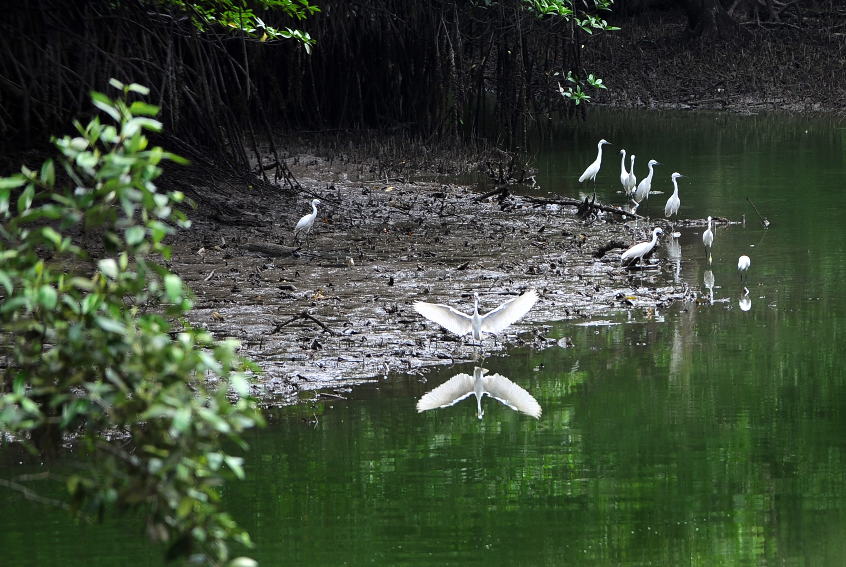
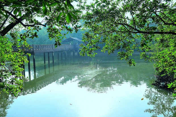
The first wetland reserve is now a 202-hectare sanctuary for a myriad species such as mudskippers, crabs, shellfish, monitor lizards, otters and more. Previously home to commercial prawn farms, the reserve is now a hotspot for migratory birds. A perfect trail for those seeking a natural experience far from the urban landscape that we are so familiar with.

PHOTO: Sungei Buloh Wetland Reserve, the Resident Monitor Lizard
Posted by miket on 26 February 2013 at 10:52 AM
https://blogger.googleusercontent.com/img/b/R29vZ2xl/AVvXsEivlNOVNReR0o7MCgldK20f533AaUTtW4gIhfeAqnmZwE8zKZDUPkW3RdKaY5EZnTT4dq2MT6Gv9VU97j6t4QvKr7ukKLvfApPyN82-dK88RJy85GpaoYtprbSRoWdNQKo_-xlVEii98m7Y/s1600/240SungeiBulohMonitorLizard49.jpg
https://blogger.googleusercontent.com/img/b/R29vZ2xl/AVvXsEjS7dPd9ahhCUVy8CbMOnI-t290TaWfKYsia3wKXEnGRWGHzIq1miz2LJPf5wOw7Fk9FGADMFGmWuueEU5jAdH_ZLK9vL8L5qTWyOvTy-c0r72eT3FC6M9K0XuZ777oWVV4QbCLtNLv3bos/s1600/240SungeiBulohMonitorLizard49.jpg
http://sgwalkingroutes.blogspot.sg/2013_02_01_archive.html
One might even get a chance to dip their toes in the natural mud spa while walking along the mudflats at low tide. If you are lucky, you might also spot a crocodile or some white-bellied sea eagles near Eagle Point.
PHOTO: Sungei Buloh Wetland Reserve, Mangrove Boardwalk
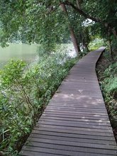
This 130ha green belt, a favourite of huge flocks of migratory shorebirds, was recognised as an ASEAN (Association of Southeast Asian Nations) heritage park in 2003, for its array of bird life as well as animals such as otters, monitor lizards and even crocodiles. Boardwalks (above) keep visitors safe – and their feet dry – as they venture deep into the mangroves to catch sight of tree climbing crabs scuttling up trunks of trees, mudskippers skimming across swamp waters and archerfish shooting insects with jets of water.
Posted by Desiree Koh on 1 September 2013 - A Walk on the Wild Side
https://blogger.googleusercontent.com/img/b/R29vZ2xl/AVvXsEi3lb_pLZTqLwhXI7_IuZR6Y23VaknC1mkxtJjMf6kBH3cDGdB-oU20ycXhE9H-1BweMroamZcDCZ_04dk9tGsakSKpbg3Ow7N6S0avuav50HSA-sWhvfiyQnEYkDOnpH319fvlAjCOYHul/s1600/1309-destinations-singapore-boardwalks-mangrove-630.jpg
https://www.silverkris.com/sites/default/files/1309-destinations-singapore-boardwalks-mangrove-630.jpg
https://www.silverkris.com/destinations/singapore/walk-wild-side
PHOTO: Sungei Buloh Wetland Reserve
Along the trails are shelters where visitors can rest or simply savour the serenity, with only the raucous call of the collared kingfisher breaking the peace.
Image credit: Andy Leo@Photography
Posted by Sabrina Muhleseddin on 20 July 2015
https://blogger.googleusercontent.com/img/b/R29vZ2xl/AVvXsEiku1zW073S3lr2yKgaLIA5hw_8ruJvfBFjoCtf6eQ-jrXlQZOF-tXSRy8t9X_anYI3-apfJbDT7NOkBrCU5_AgQ8ebJ4NW4aVIckxTb3KskGgAbUeLZb1O5zvFcvVj0XvqZuMH7IlCh8Vq/s1600/25415_620x.jpg
https://static.tripzilla.com/thumb/4/7/25415_620x.jpg
https://www.tripzilla.com/outing-ideas-singapore-under-sgd20/23400
7. Dairy Farm Nature Park

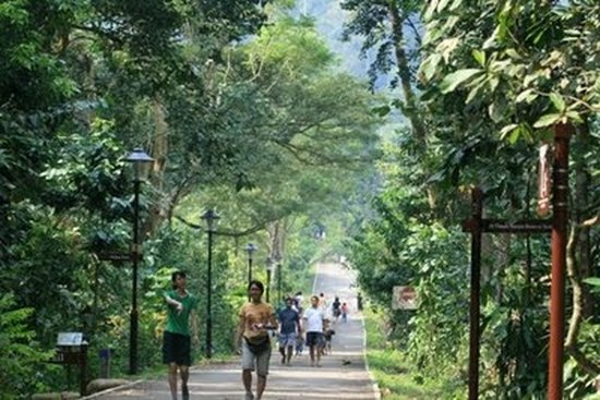
The Dairy Farm Nature Park's Wallace Trail is a 1 hour hiking journey set amidst a rustic environment.
Posted by 3 little piglets on 05 March 2010 at 09:22:28
https://blogger.googleusercontent.com/img/b/R29vZ2xl/AVvXsEgO7E1zkWWyVymT_ziZ7D49ncYx4fB3T1s-mc9Jx-J0OEFUhxwGLu6RtbMF-6yI4_iWOJGFhi-ewBJo2uNMbS9wHOxlDs5TQbBLOqf-P8Ihxd8nY7EGGcN0P0ZsD1W6WA5S9VmpX2KwNKKP/s1600/60a9a299g8103b7be63b0%2526690.jpg
http://s1.sinaimg.cn/large/60a9a299g8103b7be63b0&690 - (60a9a299g8103b7be63b0&690.jpg)
http://blog.sina.com.cn/s/blog_60a9a2990100hin8.html PHOTO: The road to Wallace Education Centre
Picture posted by bukitpanjang.com
https://blogger.googleusercontent.com/img/b/R29vZ2xl/AVvXsEiUBcXS5piC9xeQwGzpQYOkjajrlxmgzOWX_4PwijBVxXPkd26ayQ_1RtCmTsyL3iI83jLK_olCSYn24ttzoCqQ4OZegl513bTxAFZRTDHiSrRPBPz0AdfgWWLRe2jxUWJIFUaEOTNKcR8/s1600/6113507.jpg
http://www.bukitpanjang.com/uploads/2/3/7/3/23733606/6113507.jpg?550
https://www.insightguides.com/destinations/asia-pacific/singapore/singapores-outer-areas/overview
The Dairy Farm Nature Park's Wallace Trail is a 1 hour hiking journey set amidst a rustic environment. The 63-hectare park also offers a host of recreational activities and amenities, such as trails for mountain bikers.

PHOTO: Wallace Education Centre
Posted by 3 little piglets on 05 March 2010 at 09:22:28
https://blogger.googleusercontent.com/img/b/R29vZ2xl/AVvXsEi-I3rmAvMU5BUJhjHre4J8YbLyWTTi_dXjUJmkzotVferfXFseMUM-CsNGjfn-dIMx53gQrNECNIqAdeK2eAr-V7VnglCnQko7BYb3xk73AnWukBmFGzrYkTHbFZcHOZBCkNIDGRUJwsRa/s1600/60a9a299g81044467e489%2526690.jpg
http://s10.sinaimg.cn/middle/60a9a299g81044467e489&690
http://blog.sina.com.cn/s/blog_60a9a2990100hin8.html
PHOTO: Trails for mountain bikers
Photo: The Straits Times
https://blogger.googleusercontent.com/img/b/R29vZ2xl/AVvXsEgTTDxe9UZ17JEU7zEJmJgLSGw4zxQmx8bnzWAHCadS1nm4wvD1_eaH0WcSbT7jC5mqQCLOyGK1-Jh6WH079ygMgRYw8W6Co7JlXEcnsTyfrLPd8qej-ClavpRxBOE_ME-KLBhdk3C-Vsvr/s1600/14260_1474333849-2.jpg
http://www.asiaone.com/sites/default/files/inline/images/14260_1474333849.jpg
http://travel.asiaone.com/travel/inspirations/8-hiking-trails-singapore-you-should-try
Near the south-western end of the park is the Singapore Quarry, which has a viewing platform for nature lovers to appreciate the freshwater flora and fauna available there.
PHOTO: Singapore Quarry at the Bukit Timah Nature Reserve
One of the largest swathes of primary forest left in Singapore, Bukit Timah Nature Reserve is home to more than 840 flowering plants and over 500 animal species. The park also boasts Singapore’s highest peak and several winding forest trails.
Picture posted by expatliving.sg on 28 July 2013
https://blogger.googleusercontent.com/img/b/R29vZ2xl/AVvXsEiW4lvg1RZ0CFgTL9LvIhptRC3KOWISp2YJADAVDQSWXqAMqZkMRu0y0rmSOVUyFY67VNVzUifHpolfaG7omOxlN92TyOA-yVM9taEGpIAFPJ8DxDVSBBTdDn9rYoRNYvQwlCNfjNynUpLV/s1600/Green+Spots_9.jpg
http://www.expatliving.sg/Things_to_do/article16322.ece/alternates/w1024/Green%20Spots_9.jpg
http://www.expatliving.sg/Things_to_do/outdoors/10-best-green-spaces-in-Singapore-from-parks-and-gardens-to-lakes-and-reserves-5253.ece
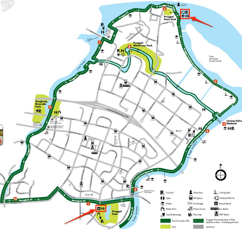
8. Punggol Promenade
One of the largest swathes of primary forest left in Singapore, Bukit Timah Nature Reserve is home to more than 840 flowering plants and over 500 animal species. The park also boasts Singapore’s highest peak and several winding forest trails.
Picture posted by expatliving.sg on 28 July 2013
https://blogger.googleusercontent.com/img/b/R29vZ2xl/AVvXsEiW4lvg1RZ0CFgTL9LvIhptRC3KOWISp2YJADAVDQSWXqAMqZkMRu0y0rmSOVUyFY67VNVzUifHpolfaG7omOxlN92TyOA-yVM9taEGpIAFPJ8DxDVSBBTdDn9rYoRNYvQwlCNfjNynUpLV/s1600/Green+Spots_9.jpg
http://www.expatliving.sg/Things_to_do/article16322.ece/alternates/w1024/Green%20Spots_9.jpg
http://www.expatliving.sg/Things_to_do/outdoors/10-best-green-spaces-in-Singapore-from-parks-and-gardens-to-lakes-and-reserves-5253.ece
8. Punggol Promenade

Photo: The Straits Times
https://blogger.googleusercontent.com/img/b/R29vZ2xl/AVvXsEh9BRc3GxiuoNuz6pAM1OBaBLGEcuvFWdAkDF3W8AP5BIUQ0A-fQZDmaH85T_jWLSfCfHe37TmiztxRUAo3ljZV4arfF33Iu2iUz9xGSTAfNZ25ZEEzEZVJ5KIbibFF0d206KObB4owb9LE/s1600/14260_1474333884.jpg
http://www.asiaone.com/sites/default/files/inline/images/14260_1474333884.jpg
http://travel.asiaone.com/travel/inspirations/8-hiking-trails-singapore-you-should-try
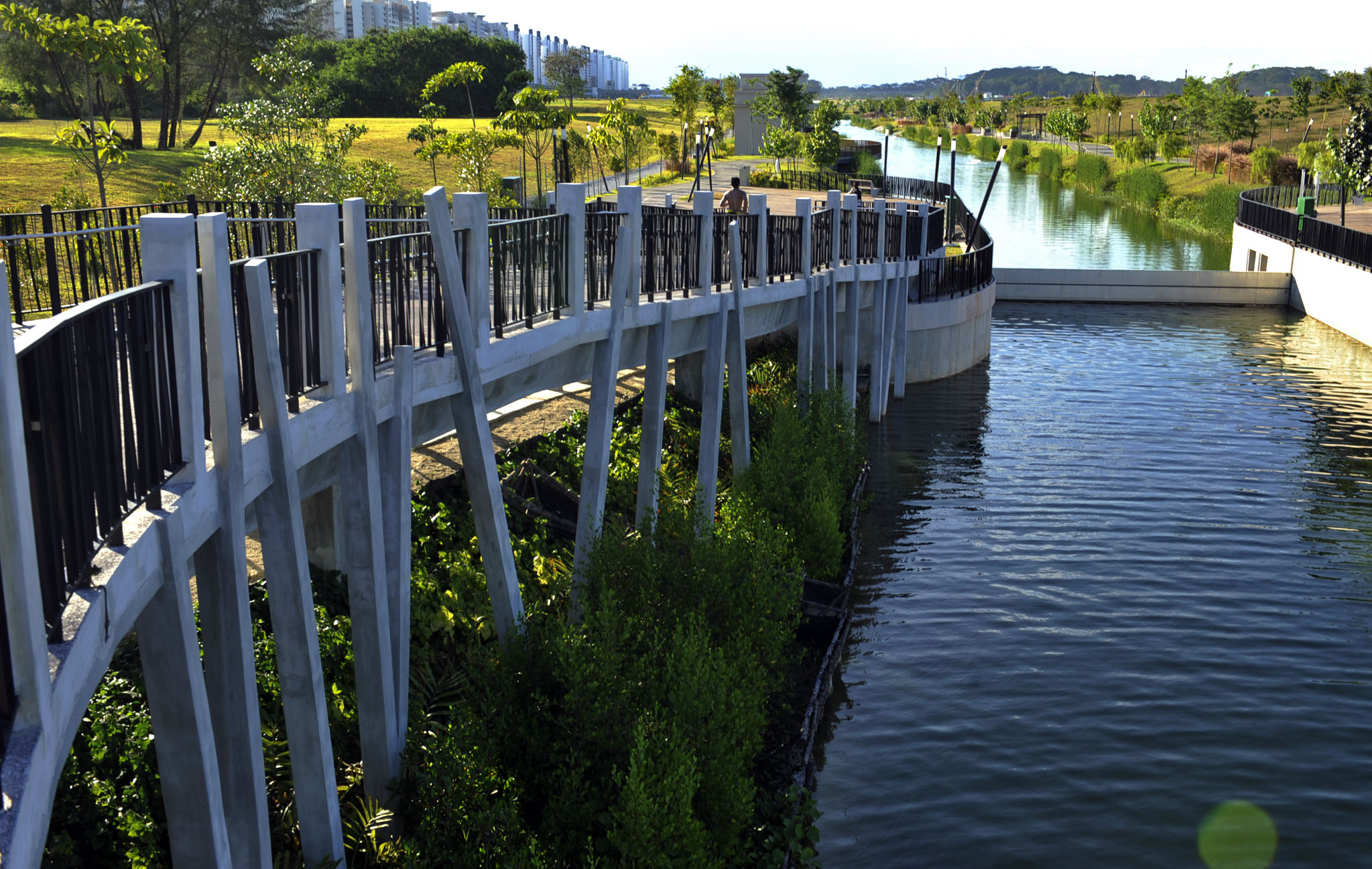
A new promenade comprising of a mix of parks and park connectors, Punggol Promenade features a 2.4km Nature Walk in the middle section between Punggol Point Walk and Riverside Walk. The idyllic waterfront destination also feature a number of fishing platforms and rest shelters along its track for visitors to take a quick respite or enjoy the scenic views.
The 17km loop around the promenade also connects to Sungei Serangoon, where visitors can visit Lorong Halus Wetland, a former landfill transformed into a wetland for birdwatchers and nature lovers.

PHOTO: The 17km loop around Eastern Riverine Park Connector Network (PCN) connecting Punggol Town, Sengkang and Hougang. Almost the whole loop is beside the reservoirs and rivers. Especially nice during Sunrise from Junction of Buangkok PC to Sengkang Riverside Park (2 km).
Picture posted by sivasothi (Flickr)
https://blogger.googleusercontent.com/img/b/R29vZ2xl/AVvXsEg-ySfTSaCdYxowxXe-ErVh6bU4D6NSVDMHi5vslea_eKwcFYG-uQJo6lze_mxKE2QITgDcnAyrtX25A9xIm24bBOlbC46smvA-8nLe46YvRD9F4rf6MOiAb209mAPfJb02E_NAd48feJhy/s1600/8421515991_b7a95fcb6f_b.jpg
https://farm9.staticflickr.com/8221/8421515991_b7a95fcb6f_b.jpg
http://picssr.com/photos/sivasothi/interesting?nsid=79855913@N00
PHOTO: Punggol Waterway Park connects to Sungei Serangoon, where visitors can visit Lorong Halus Wetland (just cross the red bridge across Sungei Serangoon), and 1 km on, Coney Island Eastern Gate.
Photo: Steel Wool, Flickr Commons
https://blogger.googleusercontent.com/img/b/R29vZ2xl/AVvXsEin-KMnOeQnEUZwV9xK72KlgBua53ya3lGDAgobLrHnoCdQcYuLe9Sutq2CsRSW33SnCthl1obTuWNYyIfTun5wW_Pf9pNafZ9pD_WDg8s5X0gGtKQHEsogu32BwiwZhAZdSJie-mdV5_A5/s1600/Punggol-Waterway-Park-credit-Steel-Wool.jpg
http://www.expatliving.sg/incoming/article77430.ece/alternates/w610/Punggol-Waterway-Park-credit-Steel-Wool.jpg
http://www.expatliving.sg/Things_to_do/things_todo_news/35-things-to-do-in-Singapore-Huge-guide-to-cool-activities-on-the-Red-Dot-77419.ece
PHOTO: Yu Chze & Serena Pre-Wedding Photoshoot at Punggol Waterway. With God's blessings, we wish them all the best in their life together.
Picture posted by Web Design by Fancy Girl Design Studio on 21 April 2015
https://blogger.googleusercontent.com/img/b/R29vZ2xl/AVvXsEiLOc7QKStMJHJm6eVje4A9zGXrYBft4LNaqIEBqIjM3Wnt49w4Qwmp7IvbUNMBUwIiLjaOdxwVii-SbVWs6HJF0OsEd6ZcIW7fiNX7T2Ql1c7BBisGW6whX_lnCV58RntYjwRiN3IsJmRU/s1600/Pre-Wedding-Photoshoot-at-Punggol-Waterway-006.jpg
http://awesomememories.com.sg/wp-content/uploads/2015/04/Pre-Wedding-Photoshoot-at-Punggol-Waterway-006.jpg
http://awesomememories.com.sg/2015/04/pre-wedding-photoshoot-at-punggol-waterway-yu-chze-serena/
Reference
Picture posted by Web Design by Fancy Girl Design Studio on 21 April 2015
https://blogger.googleusercontent.com/img/b/R29vZ2xl/AVvXsEiLOc7QKStMJHJm6eVje4A9zGXrYBft4LNaqIEBqIjM3Wnt49w4Qwmp7IvbUNMBUwIiLjaOdxwVii-SbVWs6HJF0OsEd6ZcIW7fiNX7T2Ql1c7BBisGW6whX_lnCV58RntYjwRiN3IsJmRU/s1600/Pre-Wedding-Photoshoot-at-Punggol-Waterway-006.jpg
http://awesomememories.com.sg/wp-content/uploads/2015/04/Pre-Wedding-Photoshoot-at-Punggol-Waterway-006.jpg
http://awesomememories.com.sg/2015/04/pre-wedding-photoshoot-at-punggol-waterway-yu-chze-serena/
By Geraldine Mark, Shopback, Tuesday, 20 Sepyrmber 2016
For the more laidback trekkers, the many ship-inspired, elevated lookout decks also present opportunities to soak in the coastal atmosphere and regard the views of Pulau Ubin and the Johor Straits.
For the more laidback trekkers, the many ship-inspired, elevated lookout decks also present opportunities to soak in the coastal atmosphere and regard the views of Pulau Ubin and the Johor Straits.
Reference
- https://blogger.googleusercontent.com/img/b/R29vZ2xl/AVvXsEgbbrKfoEygkOZPy6f063Oci3y8lnU-BmEorauyvqslP-mR7gwRlrxec_x73tWDs_evQyAKZ1ANFe7bENpSikePMjIl6Uhnenf6MnBq4gFz4pgZH8869GSuNjk_WZiCPlG-ER9x7uzV6VSr/s1600/en_cpphotohyl.jpg
- http://www.strangescience.net/enlar/en_cpphotohyl.jpg
- http://wesharepics.info/imageggkl-giant-lizard-monster.asp
- https://blogger.googleusercontent.com/img/b/R29vZ2xl/AVvXsEiuh5S4q9rjrCeBt86Oi0ImO7uUPhkWoya7Vg768F0jbmxqVWHqvHS3SdcaO7TrvwpPQuNXJLN9DTk2Xj0J2UACRips1FoFC9yo4KJySAeUf1Sbx5WcsR5XethC0l_w0cfFhtr3I-jpsUQk/s1600/14260_1474333681.jpg
- http://www.asiaone.com/sites/default/files/inline/images/14260_1474333681.jpg
- http://travel.asiaone.com/travel/inspirations/8-hiking-trails-singapore-you-should-try
- https://blogger.googleusercontent.com/img/b/R29vZ2xl/AVvXsEhxlDgOuNuPSXXoLwZFVHaNPVd55guMnOjOnCWA17O6bBH0fun8sD0a3-giuNp7Giz9B-QefcXQh_ZqUfCUkSIOSr_pRbrrZZoXrbKuri7F_2O5HPqkrpTg7ngfyE6Q_NmZXg-2s-3pImcn/s1600/b2ap3_medium_image09.jpg
- http://www.thesmartlocal.com/images/easyblog_articles/2626/b2ap3_medium_image09.jpg
- http://thesmartlocal.com/read/hiking-trails
- https://blogger.googleusercontent.com/img/b/R29vZ2xl/AVvXsEivHmRTRQOG6wiZFfheFihFRJC2EpLK9XLjKLKIsYE53TuNzSOj4L7C_1u8kLBGEZRS9y0LFA7qfRGndXCBiVhOCiWfhqEq1pT6r41AraBE6-lcP1cgXf1iqCR309FAOol_fPcUZYeZYuhb/s1600/1261221_orig.jpg
- http://eluxemagazine.com/wp-content/uploads/2016/02/1261221_orig.jpg
- http://eluxemagazine.com/travel/sustainable-singapore/
- https://blogger.googleusercontent.com/img/b/R29vZ2xl/AVvXsEg3BW3oNqfawgcj-Vj7EiZFTY6sZjpiEx-b4GfPdxTthedNOzd_MBWKW6Yac-cG4KaormAiX9nVsjLsOt_aZhia34lV_zyPUGor9_Dp5aEYaX6M0JQLeSZG6Mh7ruKoJ_7YsHidVAyLY5E8/s1600/Macritchie-18_20150304-072555_1.JPG
- http://thesmartlocal.com/images/easyblog_images/2337/Macritchie-18_20150304-072555_1.JPG
- http://thesmartlocal.com/read/macritchie-treetop-walk
- https://blogger.googleusercontent.com/img/b/R29vZ2xl/AVvXsEjPLI-21uosG4sspRSTwHy4qo25rtI2NFV6xFyQAqRrg2S6NXPU_iYJy_Ts2AcqBEkj447u8fRbNvpdvrNGWkCt_aGYz8IPW_PbtLz7TMa52t3ea-Ay-7USYwBia4_mLynOVS3aqFWyl7sl/s1600/b2ap3_medium_image20.jpg
- http://thesmartlocal.com/images/easyblog_articles/2626/b2ap3_medium_image20.jpg
- http://thesmartlocal.com/read/hiking-trails
- https://blogger.googleusercontent.com/img/b/R29vZ2xl/AVvXsEgmXn3gCseFT04kRHVWXSIMz7y5Ub53Z7DAJtvdPltl5mz4Gi-Sn7y9mIgZyKhWvZbcyVOIAOhoGr8LNBPtO2M2V9UI5STEP0kQbmeN_WvSPpUNCkywkqdMyxqTguf_saS-OE6JTx2cTmlJ/s1600/P1110277.JPG
- http://3.bp.blogspot.com/-KJWLnESkSLA/UR8Ew_3A3WI/AAAAAAAATfI/3lRiV764LTY/s1600/P1110277.JPG
- http://wodejiaoying.blogspot.sg/2012/02/bukit-timah-nature-reserve.html
- https://blogger.googleusercontent.com/img/b/R29vZ2xl/AVvXsEgvVtjhRBHGlXn5-7v9R5XAcJz4ROl9jww0IK8ypytaKIu9u1OUey5kE_9uWJTP8-_D-wSiHOLjjDJ1Ltgs7r4Al8Gx0EM_Ho9lfyaTZjla-eyZdYkmP-IfIBOqHwMM0ZiB2HIyXX-p0z0/s1600/eea74d7d-88be-4a7b-8676-ee75dba74293.jpg
- https://d3vonci41uckcv.cloudfront.net/old-images/original/eea74d7d-88be-4a7b-8676-ee75dba74293.jpg
- https://www.insightguides.com/destinations/asia-pacific/singapore/singapores-outer-areas/overview
- https://blogger.googleusercontent.com/img/b/R29vZ2xl/AVvXsEhYuZK0rT8owDbMNfZ9YM1VhTzwX6co2lx_0DpVrrw6HKAeHVhJYGew_yncUwZMTebQgleAOzVSnJmnT6D3yKwGM6AUoKKyTGiX5s-ivsMvVtAaUt969BA3Sh9n2E9ECLErvnq_hzqJugVX/s1600/Southern+Ridges+Flickr+Kenneth+Pinto.jpg
- http://www.expatliving.sg/incoming/article77427.ece/alternates/w1024/Southern%20Ridges%20Flickr%20Kenneth%20Pinto.jpg
- http://www.expatliving.sg/Things_to_do/things_todo_news/35-things-to-do-in-Singapore-Huge-guide-to-cool-activities-on-the-Red-Dot-77419.ece
- https://blogger.googleusercontent.com/img/b/R29vZ2xl/AVvXsEhI_JN-DDXRK0S0wn6SCCKm5nGvmcWKKI2CzhbJNZ9oj7gIUyoMBKSkNrzB2Li-kad5QaXz8DrUPGwIhX0Okq3fSEQ2RgFiTN_F_x1Iw3eMsvVZq3FhDGmYzW7P7hzQlGWaic0-lTo67c0m/s1600/dscn3962_crop-659x494.jpg
- http://singaporewest.sg/wp-content/uploads/2015/07/dscn3962_crop-659x494.jpg
- http://singaporewest.sg/go/5-must-explore-jogging-trails/
- https://blogger.googleusercontent.com/img/b/R29vZ2xl/AVvXsEh-b1e8XA8z-l9_rgFZHRqVyz0vK2fCOX_12wjV_bhIkaFicuoeCqGPhcUwi02HeXoT55gsSbSOcJ_iVFU306h2zTkMjWsbScbFMQk68zLpmiNfTgu-OlN9ewWQeYhOhgb_rSfTDISKI3aM/s1600/b2ap3_medium_image15.jpg
- http://thesmartlocal.com/images/easyblog_articles/2626/b2ap3_medium_image15.jpg
- http://thesmartlocal.com/read/hiking-trails
- https://blogger.googleusercontent.com/img/b/R29vZ2xl/AVvXsEjdPWUIIOEu2soEZrr8ytTVKXy9ZFWCTjMDudvEyV1qx1_I5gMXExYf1iFDhPplXHjFptaEh5JrDRpjVHDHen1gJD6tD9qSBnnGq11mrXDk2uXUKNIgfq-OLiWi4Voy0smN5lueLvT_tKgc/s1600/202440850_6d85813584.jpg
- https://c1.staticflickr.com/1/62/202440850_6d85813584.jpg
- https://www.flickr.com/photos/gerardgoh/202440850
- https://blogger.googleusercontent.com/img/b/R29vZ2xl/AVvXsEhquIGmLe617d2XHpitrq9NNbfLKHfTgNCMWJrOqLn4O17yNJf22F-Sr7q5CVSNLGKLS3o4ZsuSCPC-NH8Fj5RrPbdYRiIcg8bdXdZu9XgMjXZOd3JN3PfXX5TxCvj10xq7QunkjT6omIhA/s1600/Pulau-Ubin-28.JPG
- http://thesmartlocal.com/images/easyblog_images/2304/Pulau-Ubin-28.JPG
- http://thesmartlocal.com/read/instawalk-ubin
- https://blogger.googleusercontent.com/img/b/R29vZ2xl/AVvXsEjmLpa7H2R32RDmcaYGDQXoaozkMR7rBzpGwOyWbqo03kMjC-bxAb2l-S7X_qSS4fioecbd2TtvgW4c3Co14ORO9zf5Os8FxDxgZyMRsjH1wIGu3l99pKGFkPFPtrdKlXhe1SVn6E1jNmrm/s1600/img_4374-1.jpg
- https://jobynateo.files.wordpress.com/2014/08/img_4374.jpg
- https://jobynateo.wordpress.com/2014/04/20/nature-singapore-pulau-ubin/
- https://blogger.googleusercontent.com/img/b/R29vZ2xl/AVvXsEg4QWLxAhBSppPu3RAxzoaup1hbm7bmJWKN318lEe3I3mfdfdue8-ZFSUKxyNGEQrcOlw-ksAzm2TSNaGl0Y8ac21FthDwja3QjmBfT_1PKIFWEPehvf07O_tMG8jBRVCloZ-zZMAPa7JjW/s1600/510.jpg
- https://travelezeuk.files.wordpress.com/2015/08/510.jpg
- https://travelezeuk.wordpress.com/2015/08/12/the-unfathomable-green-shelters-of-singapore/
- https://blogger.googleusercontent.com/img/b/R29vZ2xl/AVvXsEh4IcQ3xoTAbr2l7ilzmTZmKvASV_5nAc6xpU7wiR_0TNpIde5tNOIyY4U0JKamQVv3aB6JS6XJYOFyaRXS9zQtWPtY-1akCjh1NS8zATNYqVVZKHB3fSWaPGdbtxGHHOcNMQ3YkpLwkNi0/s1600/310.jpg
- https://travelezeuk.files.wordpress.com/2015/08/310.jpg
- https://travelezeuk.wordpress.com/2015/08/12/the-unfathomable-green-shelters-of-singapore/
- https://blogger.googleusercontent.com/img/b/R29vZ2xl/AVvXsEg1wrNjsnUB8JfhZT1WAH1dzI_AArlve8wpaJOecgD6dD_YVh6Ne-9i5Vth22wQrJKzDu3e5hjkWyqwmOsIoP5LW-cKrkYmYDTg2vX0232rcy0LRoXz7a_ttNiEbxHSh8e685WsKLaztFfw/s1600/img_2938.jpg
- https://bugsandinsects.files.wordpress.com/2015/09/img_2938.jpg
- https://bugsandinsects.wordpress.com/tag/the-green-corridor/
- https://blogger.googleusercontent.com/img/b/R29vZ2xl/AVvXsEh9TMXN-FpAwRE1Srt-9_AQKlMuMEv3H0wNrORfNERk0qeGpqCyvnQVib_Ar3epL2_rX0hDNiMJzdUzNPHXeSEhLPF-RQWFSWPiDUGr3LCujCnaJ0VlUJq5Fn6MtRGS8bKU76XM_3ptQ2Mc/s1600/2T2J3917.jpg
- http://www.photojournalist-tgh.tv/wp-content/uploads/2013/01/2T2J3917.jpg
- http://www.photojournalist-tgh.tv/photojournalism/green-corridor-run-2013
- https://blogger.googleusercontent.com/img/b/R29vZ2xl/AVvXsEgBPnu5QfYTw0Kjwau2-6HNDSN0GjT45WwvFAYxeHfOu_qet4VjxAV27_dx_EBQibUpBrs0wLvnGJzu6NIa37LMt2OT9CiWqx982n2YtjG4hcVis4SmKR1352z1wCzBzD20SWQ6pMFNElrp/s1600/37053694_-_28_12_2015_-_xhassumption28.jpg
- http://www.straitstimes.com/sites/default/files/styles/article_pictrure_780x520_/public/articles/2015/12/29/37053694_-_28_12_2015_-_xhassumption28.jpg?itok=58gQsfHv
- http://www.straitstimes.com/singapore/education/long-winding-road-to-new-school
- https://blogger.googleusercontent.com/img/b/R29vZ2xl/AVvXsEjZ8Nltoq3pMiuDYCk-TxyIctV2sFqpNq9R0zqV3uhPhEN3DWOVwlFLwi-I0Tv_g_M3vywgb73NBWGK0ycNibNMvYgzEo1vVg7cBDkjReEKGRgjuU_g1lWZh1A5P95nPyVmAUzkp7cLBFF6/s1600/6_2.jpg
- http://iflaonline.org/wp-content/uploads/2015/12/6_2.jpg
- http://iflaonline.org/2016/01/pop-up-urbanism-a-future-for-southeast-asia/
- https://blogger.googleusercontent.com/img/b/R29vZ2xl/AVvXsEhhnPwCgJeciT5XyBBP9tMStkfZo6jqG1ou-xameL7TtpScNRKV2c7K-KjMTltFVY2N0rq2MszNcV8-cH02JmCiT6CzJtC84jCpca7TLCrOKju_H3CD8CBC22IoMgKavXHQcEjQgKS8vZ2A/s1600/14260_1474333821.jpg
- http://www.asiaone.com/sites/default/files/inline/images/14260_1474333821.jpg
- http://travel.asiaone.com/travel/inspirations/8-hiking-trails-singapore-you-should-try
- https://blogger.googleusercontent.com/img/b/R29vZ2xl/AVvXsEivlNOVNReR0o7MCgldK20f533AaUTtW4gIhfeAqnmZwE8zKZDUPkW3RdKaY5EZnTT4dq2MT6Gv9VU97j6t4QvKr7ukKLvfApPyN82-dK88RJy85GpaoYtprbSRoWdNQKo_-xlVEii98m7Y/s1600/240SungeiBulohMonitorLizard49.jpg
- https://blogger.googleusercontent.com/img/b/R29vZ2xl/AVvXsEjS7dPd9ahhCUVy8CbMOnI-t290TaWfKYsia3wKXEnGRWGHzIq1miz2LJPf5wOw7Fk9FGADMFGmWuueEU5jAdH_ZLK9vL8L5qTWyOvTy-c0r72eT3FC6M9K0XuZ777oWVV4QbCLtNLv3bos/s1600/240SungeiBulohMonitorLizard49.jpg
- http://sgwalkingroutes.blogspot.sg/2013_02_01_archive.html
- https://blogger.googleusercontent.com/img/b/R29vZ2xl/AVvXsEi3lb_pLZTqLwhXI7_IuZR6Y23VaknC1mkxtJjMf6kBH3cDGdB-oU20ycXhE9H-1BweMroamZcDCZ_04dk9tGsakSKpbg3Ow7N6S0avuav50HSA-sWhvfiyQnEYkDOnpH319fvlAjCOYHul/s1600/1309-destinations-singapore-boardwalks-mangrove-630.jpg
- https://www.silverkris.com/sites/default/files/1309-destinations-singapore-boardwalks-mangrove-630.jpg
- https://www.silverkris.com/destinations/singapore/walk-wild-side
- https://blogger.googleusercontent.com/img/b/R29vZ2xl/AVvXsEiku1zW073S3lr2yKgaLIA5hw_8ruJvfBFjoCtf6eQ-jrXlQZOF-tXSRy8t9X_anYI3-apfJbDT7NOkBrCU5_AgQ8ebJ4NW4aVIckxTb3KskGgAbUeLZb1O5zvFcvVj0XvqZuMH7IlCh8Vq/s1600/25415_620x.jpg
- https://static.tripzilla.com/thumb/4/7/25415_620x.jpg
- https://www.tripzilla.com/outing-ideas-singapore-under-sgd20/23400
- https://blogger.googleusercontent.com/img/b/R29vZ2xl/AVvXsEgO7E1zkWWyVymT_ziZ7D49ncYx4fB3T1s-mc9Jx-J0OEFUhxwGLu6RtbMF-6yI4_iWOJGFhi-ewBJo2uNMbS9wHOxlDs5TQbBLOqf-P8Ihxd8nY7EGGcN0P0ZsD1W6WA5S9VmpX2KwNKKP/s1600/60a9a299g8103b7be63b0%2526690.jpg
- http://s1.sinaimg.cn/large/60a9a299g8103b7be63b0&690 - (60a9a299g8103b7be63b0&690.jpg)
- http://blog.sina.com.cn/s/blog_60a9a2990100hin8.html
- https://blogger.googleusercontent.com/img/b/R29vZ2xl/AVvXsEiUBcXS5piC9xeQwGzpQYOkjajrlxmgzOWX_4PwijBVxXPkd26ayQ_1RtCmTsyL3iI83jLK_olCSYn24ttzoCqQ4OZegl513bTxAFZRTDHiSrRPBPz0AdfgWWLRe2jxUWJIFUaEOTNKcR8/s1600/6113507.jpg
- http://www.bukitpanjang.com/uploads/2/3/7/3/23733606/6113507.jpg?550
- https://www.insightguides.com/destinations/asia-pacific/singapore/singapores-outer-areas/overview
- https://blogger.googleusercontent.com/img/b/R29vZ2xl/AVvXsEi-I3rmAvMU5BUJhjHre4J8YbLyWTTi_dXjUJmkzotVferfXFseMUM-CsNGjfn-dIMx53gQrNECNIqAdeK2eAr-V7VnglCnQko7BYb3xk73AnWukBmFGzrYkTHbFZcHOZBCkNIDGRUJwsRa/s1600/60a9a299g81044467e489%2526690.jpg
- http://s10.sinaimg.cn/middle/60a9a299g81044467e489&690
- http://blog.sina.com.cn/s/blog_60a9a2990100hin8.html
- https://blogger.googleusercontent.com/img/b/R29vZ2xl/AVvXsEgTTDxe9UZ17JEU7zEJmJgLSGw4zxQmx8bnzWAHCadS1nm4wvD1_eaH0WcSbT7jC5mqQCLOyGK1-Jh6WH079ygMgRYw8W6Co7JlXEcnsTyfrLPd8qej-ClavpRxBOE_ME-KLBhdk3C-Vsvr/s1600/14260_1474333849-2.jpg
- http://www.asiaone.com/sites/default/files/inline/images/14260_1474333849.jpg
- http://travel.asiaone.com/travel/inspirations/8-hiking-trails-singapore-you-should-try
- https://blogger.googleusercontent.com/img/b/R29vZ2xl/AVvXsEiW4lvg1RZ0CFgTL9LvIhptRC3KOWISp2YJADAVDQSWXqAMqZkMRu0y0rmSOVUyFY67VNVzUifHpolfaG7omOxlN92TyOA-yVM9taEGpIAFPJ8DxDVSBBTdDn9rYoRNYvQwlCNfjNynUpLV/s1600/Green+Spots_9.jpg
- http://www.expatliving.sg/Things_to_do/article16322.ece/alternates/w1024/Green%20Spots_9.jpg
- http://www.expatliving.sg/Things_to_do/outdoors/10-best-green-spaces-in-Singapore-from-parks-and-gardens-to-lakes-and-reserves-5253.ece
- https://blogger.googleusercontent.com/img/b/R29vZ2xl/AVvXsEh9BRc3GxiuoNuz6pAM1OBaBLGEcuvFWdAkDF3W8AP5BIUQ0A-fQZDmaH85T_jWLSfCfHe37TmiztxRUAo3ljZV4arfF33Iu2iUz9xGSTAfNZ25ZEEzEZVJ5KIbibFF0d206KObB4owb9LE/s1600/14260_1474333884.jpg
- http://www.asiaone.com/sites/default/files/inline/images/14260_1474333884.jpg
- http://travel.asiaone.com/travel/inspirations/8-hiking-trails-singapore-you-should-try
- https://blogger.googleusercontent.com/img/b/R29vZ2xl/AVvXsEg-ySfTSaCdYxowxXe-ErVh6bU4D6NSVDMHi5vslea_eKwcFYG-uQJo6lze_mxKE2QITgDcnAyrtX25A9xIm24bBOlbC46smvA-8nLe46YvRD9F4rf6MOiAb209mAPfJb02E_NAd48feJhy/s1600/8421515991_b7a95fcb6f_b.jpg
- https://farm9.staticflickr.com/8221/8421515991_b7a95fcb6f_b.jpg
- http://picssr.com/photos/sivasothi/interesting?nsid=79855913@N00
- https://blogger.googleusercontent.com/img/b/R29vZ2xl/AVvXsEin-KMnOeQnEUZwV9xK72KlgBua53ya3lGDAgobLrHnoCdQcYuLe9Sutq2CsRSW33SnCthl1obTuWNYyIfTun5wW_Pf9pNafZ9pD_WDg8s5X0gGtKQHEsogu32BwiwZhAZdSJie-mdV5_A5/s1600/Punggol-Waterway-Park-credit-Steel-Wool.jpg
- http://www.expatliving.sg/incoming/article77430.ece/alternates/w610/Punggol-Waterway-Park-credit-Steel-Wool.jpg
- http://www.expatliving.sg/Things_to_do/things_todo_news/35-things-to-do-in-Singapore-Huge-guide-to-cool-activities-on-the-Red-Dot-77419.ece
- https://blogger.googleusercontent.com/img/b/R29vZ2xl/AVvXsEiLOc7QKStMJHJm6eVje4A9zGXrYBft4LNaqIEBqIjM3Wnt49w4Qwmp7IvbUNMBUwIiLjaOdxwVii-SbVWs6HJF0OsEd6ZcIW7fiNX7T2Ql1c7BBisGW6whX_lnCV58RntYjwRiN3IsJmRU/s1600/Pre-Wedding-Photoshoot-at-Punggol-Waterway-006.jpg
- http://awesomememories.com.sg/wp-content/uploads/2015/04/Pre-Wedding-Photoshoot-at-Punggol-Waterway-006.jpg
- http://awesomememories.com.sg/2015/04/pre-wedding-photoshoot-at-punggol-waterway-yu-chze-serena/


.jpg)
.gif)


